Skip to content
Let's talk

Environmental intelligence powered by science and technology.

ClimateScope develops environmental decision-support tools for identifying, assessing and transforming illegal landfills into Nature-based Solution projects.

A connected path from spatial evidence to site action.

Landfill Watch shows where to look. L2NbS Framework defines what to do next. Landfill Watch identifies and prioritizes suspected landfill sites across large territories. The L2NbS Framework translates selected sites into field-based assessment, restoration scenarios and long-term monitoring indicators.

01Global product

Landfill Watch

See where action is needed. Landfill Watch turns satellite imagery and contextual data into a clear view of suspected waste sites—where they are, how they are changing and which places need attention first.

  • Detect suspected waste sites across large territories using Earth observation and AI.
  • Monitor landfill risks using indicators such as GHG emissions, expansion patterns and groundwater pollution.
  • Prioritize sites for inspection, enforcement and planning.
  • Provide spatial evidence through reports, data exports and a user-friendly interface.
Explore Landfill Watch
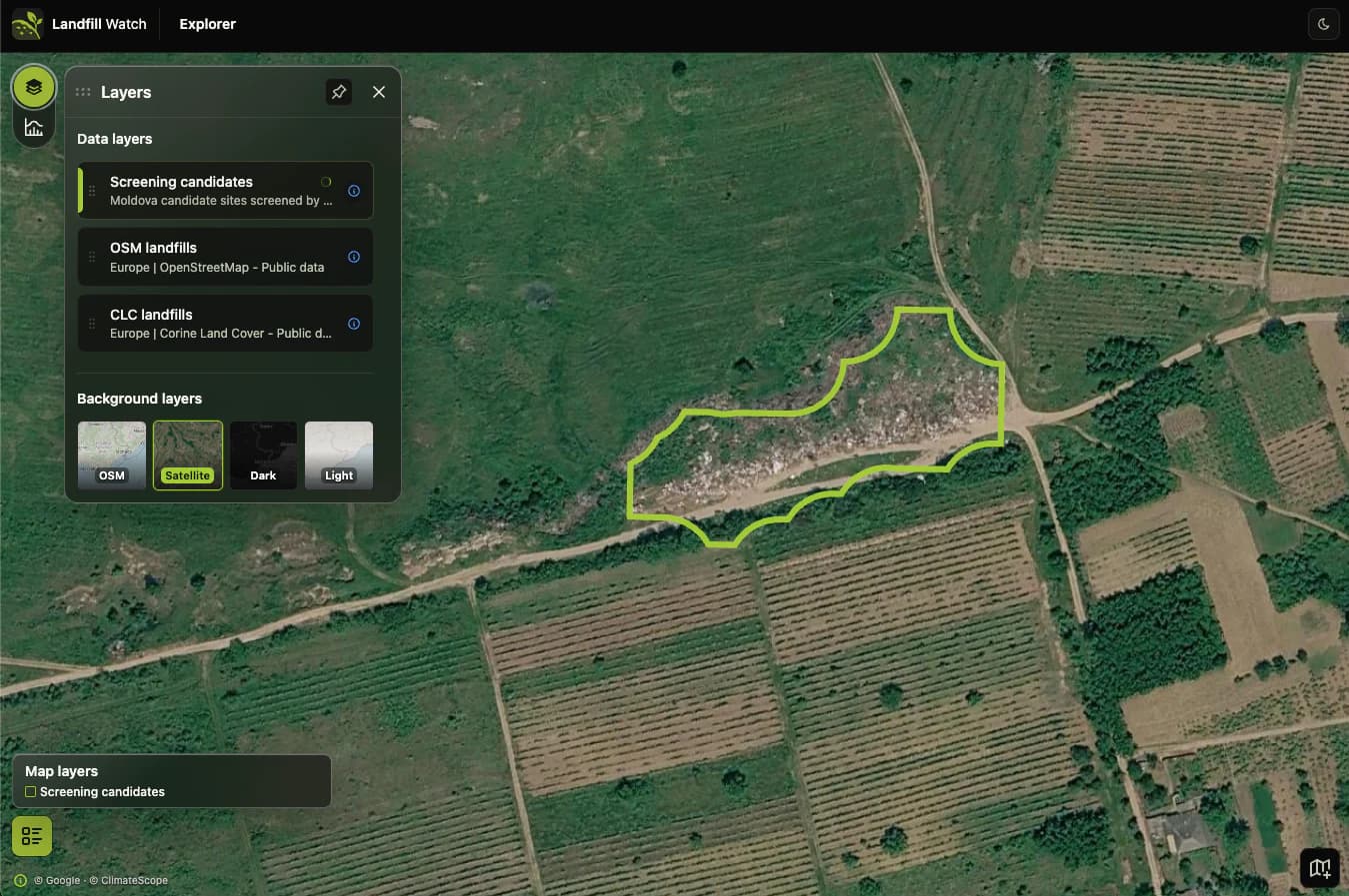
Landfill Watch Explorer showing a screening candidate outlined on satellite imagery beside data-layer controls.
Territorial screening brings suspected sites, contextual layers and review priorities into one map-based view.

02Local product

Restoration Framework

Decide what happens next. Landfill to Nature-based Solutions framework turns site evidence and local knowledge into a practical pathway for restoration, productive reuse and long-term monitoring.

  • Assess site conditions using spatial analysis and UAV-supported field inspection.
  • Select restoration, productive-reuse or utilization scenarios.
  • Identify environmental risks, constraints and local opportunities.
  • Define indicators for long-term site monitoring.
Explore L2NbS Framework
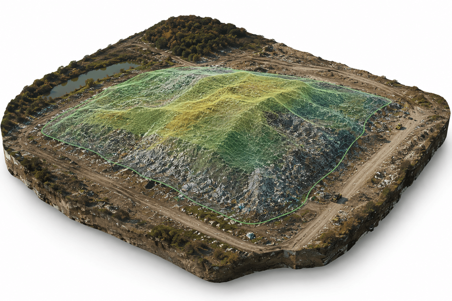
Oblique 3D rendering of a landfill site with an outlined, color-shaded assessment area.
A 3D site baseline clarifies the landfill’s scale and terrain before restoration planning begins.

Turning illegal landfills into practical restoration decisions.

The challenge moves between scales: screening suspected sites across large territories, validating conditions locally, and selecting appropriate restoration or reuse pathways.

01

Screen at territorial scale

Use Earth observation, AI and contextual layers to identify and prioritize suspected waste sites across large territories.

02

Assess at site scale

Combine spatial analysis, UAV-supported field inspection and local knowledge to understand conditions, risks and constraints.

03

Plan the transformation

Select restoration, productive-reuse or Nature-based Solution pathways and define indicators for long-term monitoring.

A consistent chain from spatial evidence to site-level action.

The products work together from detecting suspected sites to defining restoration, reuse or Nature-based Solution pathways with stakeholders.

  1. 01Identify

    Detect suspected sites

    Use Earth observation data, AI and contextual layers to identify sites for review.

  2. 02Prioritize

    Rank what needs attention

    Prioritize sites by risk, feasibility and decision relevance.

  3. 03Validate

    Confirm site conditions

    Confirm site conditions with field evidence and local knowledge.

  4. 04Transform

    Define the pathway

    Define restoration, reuse or Nature-based Solution pathways with stakeholders.

From screening candidates to practical site decisions.

Large-territory intelligence and local assessment support different decisions along the same environmental workflow.

  • Risk-informed site prioritization

    Rank suspected sites for inspection, enforcement and planning using risk indicators and decision context.

  • Field-based site validation

    Confirm site conditions through spatial analysis, UAV-supported inspection, field evidence and local knowledge.

  • Restoration and monitoring pathways

    Define restoration, productive-reuse or Nature-based Solution pathways and long-term monitoring indicators.

Space-enabled innovation, backed in the Czech Republic.

Supported by the Czech space innovation ecosystem, ClimateScope transforms Earth observation, UAV data, and geospatial intelligence into practical environmental solutions for business, governments, industry, and research.

ClimateScope is supported by ESA BIC Czech Republic, and CzechInvest.